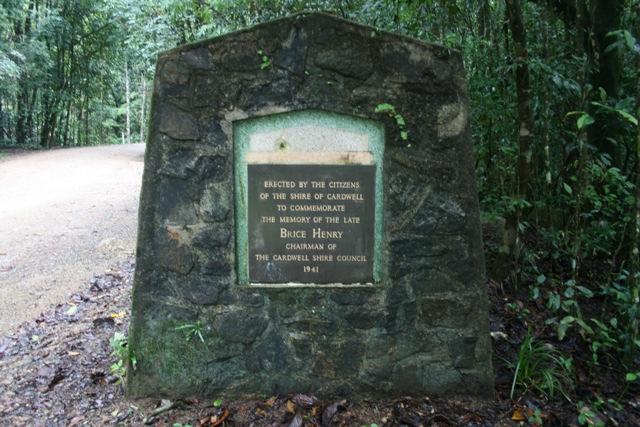
Bryce Henry Monument
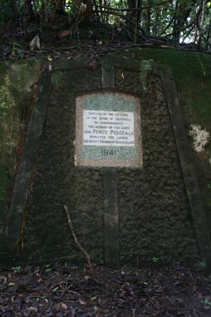
Percy Pease Monument
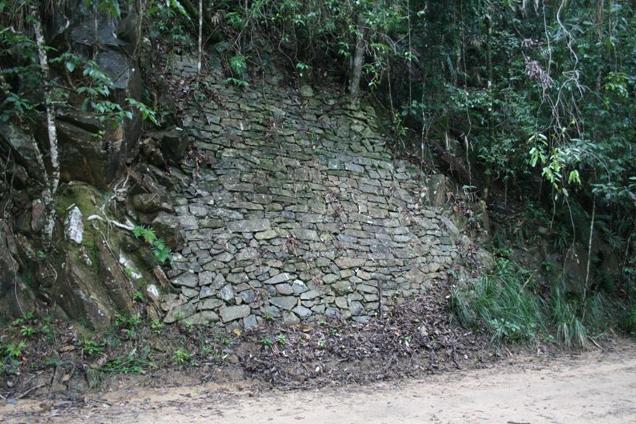
Dry Stoned Pitched Wall
No. 7 Bridge
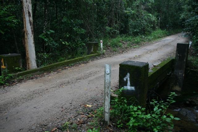
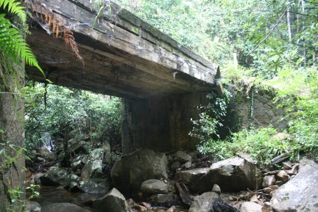
No. 1 Bridge
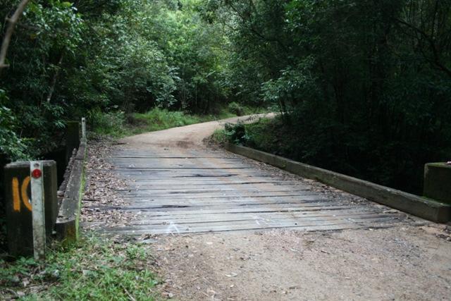
No. 10 Bridge
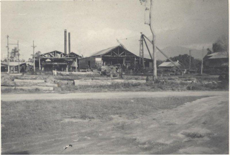
Saw Mill at Kennedy
|
History The Kirrama Range Road was the first built road over the Cardwell Range that linked Cardwell to the Atherton Tablelands.
Built as part of Queensland’s Public Estates Improvement Scheme between 1935 and 1941, it was designed to provide access to the Cardwell State Forest's rich timber resources and expand Queensland’s timber production. Prior to European settlement, the Girramai Aboriginal people developed tracks to cross the Kirrama Range behind Cardwell. During the 1870s, these were used as pack tracks for miners heading to the Etheridge and Gilbert goldfields, and by the gold escort. However, the steep terrain, and the declining influence of Cardwell as a port after Cairns was established in 1876, limited the use of these tracks. Timber getters were among the first settlers in far north Queensland but the lack of access road to the rich timber resources in Cardwell State Forest meant the trees remained untouched well into the 1920s. At this time, timber re-emerged as an important factor in the region’s economy. The Cardwell Shire, buoyed by its new-found status as a transportation hub after the railway arrival in 1924, was keen to promote the untapped stands of cabinet timbers to the Provisional Forestry Department. In 1929, the Inglewood Camp of the Provisional Forestry Board was transferred to the Cardwell District to carry out a Class 3 Survey of Timber Reserve 329, Kirrama. The survey ran until 1931 and involved measuring and estimating the value of the reserves timber, and assessing the economic viability of creating an access road. Eight logging areas were defined, covering an area of 10,674 acres (4 320 ha) as well as a new Kauri pine area of 1,942 acres (786 ha). They also surveyed the Windy logging area. While the survey was still in progress, Arthur E Moore’s National Party Government called for tenders to remove more than 60,000,000 superfeet of timber from the area in 1930, with the proviso that tenders include a blueprint for constructing an access road over the range to facilitate the extraction. The Cardwell Shire Council had long been desirous of a connecting road, and a reward was offered to the person who identified the most passable route. A government party, including Cardwell Shire Councillor Brice Henry, accompanied prospective tenderer Charles Lahey on a tour of the ranges to identify an acceptable route for the road. During their exploration they found extensive stands of red cedar, maple, silkwood, saffron heart, walnut, bean, kauri pine and silky oak, varieties which had the potential to stimulate local veneering and woodworking businesses.1 Lahey’s ambitious proposal included constructing 12 miles of road up to Main Roads specifications with additional extensions in order to access timber recourses on the ranges behind Tully. However, the intricate proposal required numerous government concessions which, ultimately, led to the tender being rejected. Despite this setback, the Cardwell Shire Council continued to press for the development of a range road and a jetty at Oyster Point (Cardwell). In 1932, the newly elected labour government abolished the Queensland Provisional Forestry Board and forestry became a sub-department in the Department of Lands. The Minister for Lands, Percy Pease, was the member for Herbert, a north Queensland electorate, and had an interest in the timber industry. His department also oversaw the implementation of the Public Estates Improvement (PEI) scheme, a program designed specifically to boost infrastructure and employment during the depression era and to open-up access to several Timber Reserves and State Forests. Pease’s support of the Kirrama project was crucial to its implementation. In 1935 J. Ainscow, Engineer-in-Charge of the PEI scheme, and Surveyor General J.P. Harvey arrived in Cardwell to view the proposed range road and jetty site (Oyster Point). They rejected the idea of the jetty, but approved the development of the road. Between 1935 and 1936 PEI staff surveyors GW Tucker and T Hein led survey parties locating the road route and spent many months camping and traversing steep slopes from the base camp in the Kennedy Valley. This steep and mountainous terrain presented another major engineering obstacle. High rainfall and an abundance of streams and waterways meant that special attention had to be paid to drainage and bridges. In 1937 construction of the Kirrama Range Road began under supervision of PEI Northern District Engineer G.W.P. Pheasant. It was designed to be a timber road that was wide enough for trucks and large, mechanised equipment. These specifications, however, had to be achieved in steep and treacherous terrain before heavy road making plant and earthmoving equipment was available.2 In two and a half years workers cleared six and a half miles of road using a variety of methods to clear timber and hew and blast their way through the granite cliffs. Spoil material from the benching and excavations was used to form the filled embankments over the gullies. In addition, "granite boulders in excess of 100 tons were rolled from an adjacent cut to become the base of fill embankments. The resultant fill batter slopes were observed to be very steep – approaching vertical." The road was constructed using the Macadam road technique, a method developed in the nineteenth century by Scottish road designer John Louden McAdam. This technique consisted of using well compacted stones (250mm thick) that were broken into relatively small angular pieces and then laid over a well drained and shaped natural base. Approximately 200 men worked on the construction of the Kirrama Range Road and lived in a series of four camps along the road as it was built. The base camp was located at Kennedy, the lookout camp was established at the four mile point, another camp called the Gap camp was established further up, and the last camp was at Windy point. All workers had specialized skills in either drilling, clearing, stone work, blacksmithing or explosives. A number of workers were Maltese migrants with particular skills in road work, as is evident in the bridges’ supporting stonework, and the dry stone pitching used to stabilise slopes between bridges nine and ten. Some of the labourers had worked on another PEI scheme further south, the development of the Crediton Road at Eungella (behind Mackay). Construction and development, already difficult because of the steepness of the terrain, was also hampered by the wet climate. Streams and watercourses threatened to wash away the road and, as a result, considerable money was spent on drainage through the construction of culverts and bridges to maintain its even grade. Bridges were built to standard Department of Public Works specifications. Retaining walls at bridges were constructed to prevent slippage during the wet season. Timber girders were used for each bridge and were made from either ironbark from Maryborough or white hickory from Mount Molloy. Timber slats were put over the top to make the bridge surface. Construction of the road included 11 bridges, 188 reinforced concrete pipe culverts some with multiple pipes (five of these pipe culverts are now buried) and 28 concrete box culverts of varying sizes. It also included numerous cuttings and side cuts. The road was estimated to have cost ₤250,000 in 1938. The construction of the first 13 miles (20.9 km) was completed in 1941 and tropical rainforest growth in the subsequent years has assisted to provide stable batter slope angles ranging from an estimated 65 degrees to approximately 80 degrees. The new road was initially known as the Kirrama Range Road. It started four miles from Kennedy railway siding on the North Coast line and extended to a head some 13 miles from the point of commencement. It was initially 16ft (4.88m) formation width, and this is still evident (although some widening has occurred due to logging use and erosion). The highest point in road was 2506 feet (764m) above sea-level and it was expected at the time that the road would be used as a tourist road as well as a forestry road because of its scenic attributes. The development of the road and the timber that was harvested resulted in the rejuvenation of the timber industry. In 1938, new sawmills were under construction in Kennedy and in Carruchan. Kennedy was formally surveyed and new mill housing was developed for the Standply mill. Although Carruchan was not formally surveyed, mill owners Brown and Broad also built housing for mill workers.5 Timber cutters followed the road as it was opened and camped with their families. The most prominent settlement was established at Society Flat, at the end of the first 13 miles of road. The kauris and rose gums at Society Flat were left when the area was designated a "beauty spot" in the 1950s, when the picturesque Kirrama Range Road was later part of a tourism strategy. The Kirrama Range Road was officially opened in 1941. By this time three people associated with its development and construction had died: Percy Pease, Minister for Lands (1940), Brice Henry, Chairman of the Cardwell Shire Council (1940) and Surveyor George Tucker, who fell into the Jarrah Creek during construction and drowned. Each of these men, instrumental in the development of the road, was commemorated in memorials along the road. Roadside memorials made from stone and mortar were erected for Tucker and Henry, with Tuckers being situated at a particularly picturesque lookout point now known as Tucker’s Lookout near the four mile lookout camp. A memorial tablet to Pease was sunk into the face of rock at the highest point of the road. The PEI scheme ceased to be involved with the road after the first 13 miles were completed and many of the workers left for the war effort. The Civil Construction Corp continued clearing road during the war, building another 14 miles to Kirrama Station. During the 1950s the road and bridges were repaired and upgraded. Bridges were reinforced with additional timber bearers, and timber slats were replaced with poured concrete slabs. Originally part of the Forestry Department, Kirrama Range Road was managed by Main Roads during the 1950s. It returned to Forestry control until 1988 when the World Heritage Wet Tropics listing brought all timber related industry to a halt. The lower section of the road has since been managed by the Cardwell Shire Council, now part of the Cassowary Coast Regional Council. References Dorothy Jones, Cardwell Shire Story. Book, Whole vols. Brisbane: Published for the Cardwell Shire Council by the Jacaranda Press, 1961. Dorothy Jones, Cardwell Shire Story, p.370. Connell Wagner. Kirrama Range Road Planning Study Report, 26 September 2007 p.15. E.R. Healy, Kirrama Range – track to road, Report prepared as part of JCU course, undated. |
| Kirrama Range Road Support Group |
|
